 Aerial imagery basemap.at (CC BY 4.0) · track OSM
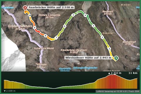
Montafoner Hut circuit | Wiesbadener Hut bis Saarbrücker Hut
Partenen
Aerial imagery basemap.at (CC BY 4.0) · track OSM
Montafoner Hut circuit | Wiesbadener Hut bis Saarbrücker Hut
Partenen
moderate
65 km of the Austrian long-distance trail 02 across the Silvretta and Rätikon: eight huts, six day stages, two countries – following the official line of the State of Vorarlberg.
The Zentralalpenweg 02 is one of Austria's ten long-distance trails, running from Hainburg on the Danube to Feldkirch. Its Montafon section is among the most alpine parts of the whole route: coming from the Tyrolean Jamtal, the path crosses the Getschnerscharte into the Bieltal and descends to the Bielerhöhe (2,032 m), climbs from the Madlenerhaus to the Saarbrücker Hütte (2,538 m), crosses the Plattenjoch to the Tübinger Hütte (2,191 m) in the Garneratal and reaches Gargellen (1,423 m) via the Vergaldner Joch. From there it continues through the Rätikon: over the Sarotla pass to the Tilisunahütte (2,211 m), down to the Lindauer Hütte (1,744 m), over the Öfapass and Verajoch to the Lünersee with the Douglasshütte (1,979 m) and finally to the Totalphütte (2,385 m) below the Schesaplana, where the trail reaches the Brandnertal.
That is about 65 km with roughly 4,000 m of ascent and 3,600 m of descent – realistically six day stages from hut to hut: Bielerhöhe – Saarbrücker Hütte, Saarbrücker – Tübinger Hütte, Tübinger Hütte – Gargellen, Gargellen – Tilisunahütte, Tilisuna – Lindauer Hütte, Lindauer Hütte – Lünersee/Totalphütte. The trail grade alternates between mountain trail and alpine route; the Plattenjoch, Vergaldner Joch and Öfapass lie above 2,400 m and may hold old snow into July. If you only want to walk parts, every stage exists as its own tour in our database (Montafon hut circuit, Via Alpina) – the long-distance trail strings them into one line. The line shown here comes from the trail network of the State of Vorarlberg (VoGIS, CC BY 4.0).
For Montafon guests the easiest entry is at the Bielerhöhe (bus from Partenen over the Silvretta high alpine road – currently, because of the road closure, via the Vermunt cable car and tunnel bus from Partenen) or in Gargellen. Waymarking: red-white-red with the number 02. Exit points at Gargellen, the Lindauer Hütte (Golm) or the Lünersee (Lünersee cable car).
Book all huts well ahead (Alpine Club members pay less). Best time mid-July to mid-September. Border crossings into Switzerland (Rätikon) are uncontrolled, but carry ID. There is no luggage transport – pack light.
Landbus 650, stop Gaschurn Versettla cable car (approx. 10 min from St. Gallenkirch); ski bus in winter.
Large free car park at the Versettla cable car in Gaschurn (summer; paid in winter).
Emergency: Alpine rescue 140 · Euro emergency 112 · Ambulance 144
All information without guarantee. Please check weather, opening hours and cable car operating times before setting off. Alpine tours require personal responsibility, suitable equipment and experience.
📚 Listed in: Vorarlberg hiking route network · Wikivoyage
Last updated: 13 Sep 2026 · Map data © OpenStreetMap contributors (ODbL) · Route line: trail network of the State of Vorarlberg (VoGIS, CC BY 4.0)
Aerial imagery basemap.at (CC BY 4.0) · track OSM
Montafoner Hut circuit | Wiesbadener Hut bis Saarbrücker Hut
Partenen
 Aerial imagery basemap.at (CC BY 4.0) · track OSM
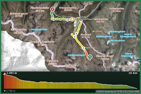
Hüttentour Silvretta - Wiesbadener Hut bis Vermuntsee
Montafon
Aerial imagery basemap.at (CC BY 4.0) · track OSM
Hüttentour Silvretta - Wiesbadener Hut bis Vermuntsee
Montafon
 Aerial imagery basemap.at (CC BY 4.0) · track OSM
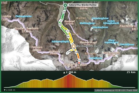
Hochtour to the Piz Buin (3.312 m)
Partenen - Bielerhöhe
Aerial imagery basemap.at (CC BY 4.0) · track OSM
Hochtour to the Piz Buin (3.312 m)
Partenen - Bielerhöhe