 Aerial imagery basemap.at (CC BY 4.0) · track OSM
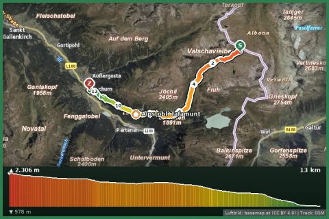
Montafoner Verwallrunde | Neue Heilbronner Hut bis Gaschurn
Montafon
Aerial imagery basemap.at (CC BY 4.0) · track OSM
Montafoner Verwallrunde | Neue Heilbronner Hut bis Gaschurn
Montafon
moderate
The northern variant of long-distance trail 02: 50 km along the Verwall crest, down to Schruns and back up into the Gauertal – four days, 3,000 m of ascent, one valley crossing.
While the main trail 02 runs south through the Silvretta, variant 02A takes the Verwall crest north of the Montafon. From the Zeinisjoch, or rather the Verbellner Winterjöchle on the Tyrolean border, it leads to the Neue Heilbronner Hütte (2,320 m) and then follows the Wormser Höhenweg over the Scheidsee, Valschavieljöchle and Grasjoch to the Wormser Hütte (2,307 m) – the scenic highlight of the route with 20 km above 2,000 m. Via Kapell the trail then descends 1,600 m to Schruns (700 m), crosses Tschagguns and the Gauertal and ends, after the re-ascent via the Gauertalhaus and Alpe Spora, at the Lindauer Hütte (1,744 m), where it meets the main trail 02.
All in all that is about 50 km with roughly 3,000 m of ascent and 3,500 m of descent – as a long-distance walk four days: Zeinisjoch – Heilbronner Hütte (short, arrival day), Heilbronner – Wormser Hütte (long), Wormser Hütte – Schruns, Schruns – Lindauer Hütte. The valley section through Schruns and Tschagguns can be shortened by bus or train; the Golm cable car saves the climb into the Gauertal if desired. Line according to the trail network of the State of Vorarlberg (VoGIS, CC BY 4.0).
Entry from the Montafon: from Partenen via Tafamunt to the Heilbronner Hütte (approach approx. 3½ h) or by Hochjoch cable car to the Wormser Hütte and then in reverse direction. Waymark 02A, red-white-red.
The Heilbronner–Wormser Hütte section is long with no refreshment stops – start early. A rest day in Schruns is worthwhile (Aquarena pool, local museum). Hut reservations required.
Montafonerbahn to Schruns station (every 30 min from Bludenz), Hochjoch cable car a 5-minute walk; Landbus 650 from St. Gallenkirch approx. 15 min.
Parking at the Hochjoch cable car in Schruns is paid and limited; alternative free parking at the Zamang cable car.
Emergency: Alpine rescue 140 · Euro emergency 112 · Ambulance 144
All information without guarantee. Please check weather, opening hours and cable car operating times before setting off. Alpine tours require personal responsibility, suitable equipment and experience.
📚 Listed in: Vorarlberg hiking route network
Last updated: 13 Sep 2026 · Map data © OpenStreetMap contributors (ODbL) · Route line: trail network of the State of Vorarlberg (VoGIS, CC BY 4.0)
Aerial imagery basemap.at (CC BY 4.0) · track OSM
Montafoner Verwallrunde | Neue Heilbronner Hut bis Gaschurn
Montafon
 Aerial imagery basemap.at (CC BY 4.0) · track OSM
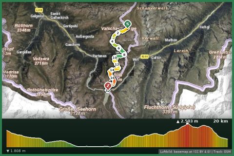
Montafoner Hut circuit | Neue Heilbronner Hut bis Silvretta-Bielerhöhe
Montafon
Aerial imagery basemap.at (CC BY 4.0) · track OSM
Montafoner Hut circuit | Neue Heilbronner Hut bis Silvretta-Bielerhöhe
Montafon
 Aerial imagery basemap.at (CC BY 4.0) · track OSM
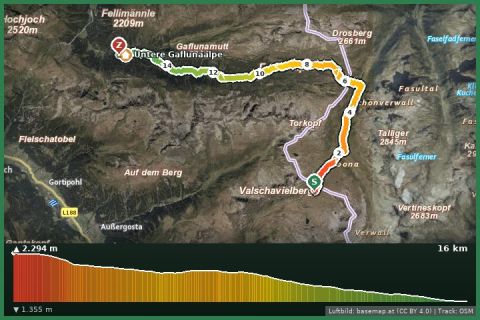
Eine idyllische Hike through das Europaschutzgebiet Verwall: Von of the Neuen Heilbronner Hut to the Unteren Gaflunaalpe
Montafon
Aerial imagery basemap.at (CC BY 4.0) · track OSM
Eine idyllische Hike through das Europaschutzgebiet Verwall: Von of the Neuen Heilbronner Hut to the Unteren Gaflunaalpe
Montafon