 Aerial imagery basemap.at (CC BY 4.0) · track OSM
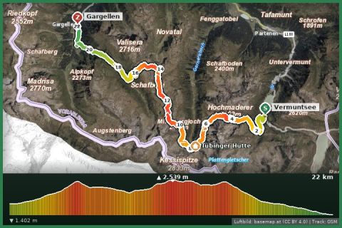
Vom Vermuntsee to Gargellen
Partenen/Bielerhöhe
Aerial imagery basemap.at (CC BY 4.0) · track OSM
Vom Vermuntsee to Gargellen
Partenen/Bielerhöhe
difficult
Demanding hike from Vermuntsee – 16.2 km, 902 m ascent, approx. 6:27 hours.
„Vom Vermuntsee ins Garneratal“ is a demanding hike starting at Vermuntsee. The route ends at Talstation Versettla Bahn.
The route measures 16.2 km, with 902 m of ascent and 1689 m of descent, pure walking time is around 6:27 hours. The highest point is at 2,506 m, the lowest at 967 m.
The route leads from Vermuntsee via Vermuntsee, Hochmadererjoch, Garneratal and Ganeu Maisäß to Talstation Versettla Bahn.
The plotted track follows the marked trails according to OpenStreetMap; see the map, elevation profile and GPX file above. Please follow the signposting on site.
Regional rating: fitness 5/6, technique 6/6.
Start early – summer afternoons often bring thunderstorms. Carry enough water; many huts are only open from late June to late September.
From the holiday house in St. Gallenkirch the starting point is easy to reach by Landbus (stop 400 m away) or car – see the travel notes.
Landbus 650 to Partenen, then Vermunt cable car + tunnel bus to the Bielerhöhe (summer 2026: 20 June–4 Oct, uphill 8–12 and 13–16:30, last descent 17:00). Approx. 1 h in total from St. Gallenkirch.
Note: the Silvretta High Alpine Road is closed on the Vorarlberg side after rockfalls, expected until 2030 – car access only from Tyrol (Galtür). The Vermunt cable car car park in Partenen is closed in 2026 for construction; use alternative parking in Partenen village.
Emergency: Alpine rescue 140 · Euro emergency 112 · Ambulance 144
All information without guarantee. Please check weather, opening hours and cable car operating times before setting off. Alpine tours require personal responsibility, suitable equipment and experience.
Last updated: 13 Sep 2026 · Map data © OpenStreetMap contributors (ODbL)
Aerial imagery basemap.at (CC BY 4.0) · track OSM
Vom Vermuntsee to Gargellen
Partenen/Bielerhöhe
 Aerial imagery basemap.at (CC BY 4.0) · track OSM
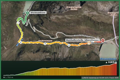
Vermuntsee - Silvretta-Bielerhöhe
Partenen/Bielerhöhe
Aerial imagery basemap.at (CC BY 4.0) · track OSM
Vermuntsee - Silvretta-Bielerhöhe
Partenen/Bielerhöhe
 Aerial imagery basemap.at (CC BY 4.0) · track OSM
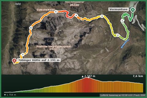
Vermuntsee – Tübinger Hut
Partenen/Bielerhöhe
Aerial imagery basemap.at (CC BY 4.0) · track OSM
Vermuntsee – Tübinger Hut
Partenen/Bielerhöhe