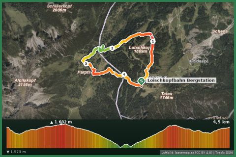
 Aerial imagery basemap.at (CC BY 4.0) · track OSM
Loischkopf loop (Bürserberg)
Bürserberg · Brandnertal
Aerial imagery basemap.at (CC BY 4.0) · track OSM
Loischkopf loop (Bürserberg)
Bürserberg · Brandnertal
easy 👨👩👧 Family friendly 🎫 Card
The 400 km circular trail around all of Vorarlberg spends 115 km in the Montafon and Verwall: from Brand via Lünersee, Lindauer Hütte, Gargellen, Bielerhöhe and Heilbronner Hütte to the Arlberg – eight hut stages in one line.
“Min Weag” – dialect for “my way” – is Vorarlberg's circular long-distance trail opened in 2016: 31 stages and about 400 km once around the whole state. The southern, most alpine part runs through the Montafon, and this map shows exactly that section following the official line of the state (VoGIS, CC BY 4.0): from the Brandnertal the trail climbs to the Lünersee (1,970 m), crosses the Rätikon via the Verajoch and Öfapass to the Lindauer Hütte (1,744 m) and via the Bilkengrat area to the Tilisunahütte (2,211 m), descends to Gargellen and gains the Silvretta via the Rongg alp and the Vergaldner Joch: Tübinger Hütte (2,191 m), Plattenjoch, Saarbrücker Hütte (2,538 m), Madlenerhaus and Bielerhöhe (2,032 m). From there it switches to the Verwall – over the Zeinisjoch to the Neue Heilbronner Hütte (2,320 m) and on along the main ridge to Stuben am Arlberg, where the Klostertal stages begin.
That is 115 km, about 7,500 m of ascent and eight day stages of 12 to 20 km, always ending at a hut or village. Here the Min Weag mostly uses the same paths as the Zentralalpenweg 02 and the Montafon hut circuit – making it the longest continuous line through our mountains. Entry points for guests of the holiday house: Gargellen (bus 655 from Gortipohl), Bielerhöhe (Vermunt cable car and tunnel bus from Partenen) or Latschau/Golm for the Lindauer Hütte.
Waymarked “Min Weag” (green-and-white logo) in addition to normal hiking signage. Stage points with bus/rail access: Brand, Gargellen, Bielerhöhe (summer), Stuben. In between, huts only.
Book huts early – August weekends fill up fast. Passes above 2,400 m: no crampons needed, but expect old snow until early July. The Bielerhöhe – Heilbronner Hütte stage is long; the Zeinisjoch has a place to eat.
Landbus 670 Schruns–St. Gallenkirch–Gargellen (hourly), stop Gargellen Schafberg cable car; approx. 20 min from St. Gallenkirch.
Free parking at the Schafberg cable car in Gargellen and at the end of the village (Vergalden).
Emergency: Alpine rescue 140 · Euro emergency 112 · Ambulance 144
All information without guarantee. Please check weather, opening hours and cable car operating times before setting off. Alpine tours require personal responsibility, suitable equipment and experience.
📚 Listed in: Vorarlberg hiking route network
Last updated: 13 Sep 2026 · Map data © OpenStreetMap contributors (ODbL) · Route line: trail network of the State of Vorarlberg (VoGIS, CC BY 4.0)
Aerial imagery basemap.at (CC BY 4.0) · track OSM
Loischkopf loop (Bürserberg)
Bürserberg · Brandnertal
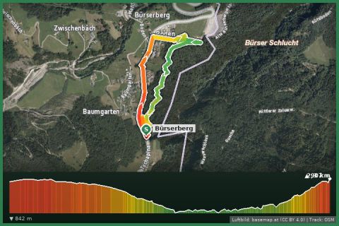 Aerial imagery basemap.at (CC BY 4.0) · track OSM
Schaftobel loop (Bürserberg)
Bürserberg · Brandnertal
Aerial imagery basemap.at (CC BY 4.0) · track OSM
Schaftobel loop (Bürserberg)
Bürserberg · Brandnertal
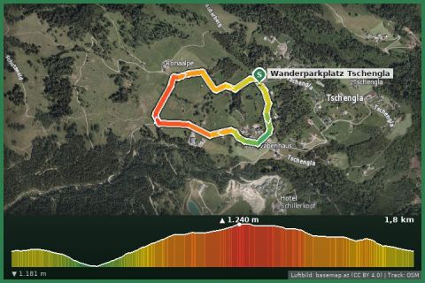 Aerial imagery basemap.at (CC BY 4.0) · track OSM
Tschengla loop to the stone circles
Bürserberg · Brandnertal
Aerial imagery basemap.at (CC BY 4.0) · track OSM
Tschengla loop to the stone circles
Bürserberg · Brandnertal