 Aerial imagery basemap.at (CC BY 4.0) · track OSM
Bartholomäberg via Rellseck to the Fritzensee
Montafon
Aerial imagery basemap.at (CC BY 4.0) · track OSM
Bartholomäberg via Rellseck to the Fritzensee
Montafon
moderate ❄️ winter
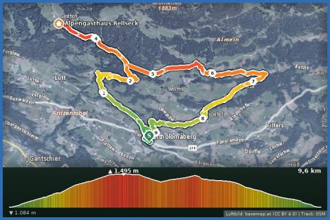
Via Linda and Goritschang up to the Rellseck (1,496 m): 8.2 km, 412 m of ascent, 3½ hours through woods and Maisäß meadows – in clear weather as far as the Säntis.
The Rellseck is the viewing balcony above Bartholomäberg, and this is the quieter way up: from the baroque church (1,087 m) follow the Lindaweg to the hamlet of Linda and climb via Goritschang through the forest to the snowy Maisäß meadows below the Rellseck at 1,496 m. At the top the view opens onto the Vandanser Steinwand and the Zimba, into the Gauertal to the Drei Türme, out to the Walgau and, in clear air, as far as the Säntis in Switzerland; on the way down the whole Montafon lies before you. 8.16 km, 412 m of ascent, about 3½ hours, moderate – mostly on cleared forest tracks, rolled higher up. If you prefer to close the loop differently, you can return via Chrestlis Egg.
From our house it is 20 minutes by car (car park at the church) or bus 650 to Schruns and bus 640 to Bartholomäberg Kirche. The Alpengasthaus Rellseck at the top is run by the Hotel Bergerhof and is not reliably open in winter – please phone ahead and bring provisions. Otherwise the inns in Bartholomäberg serve refreshments.
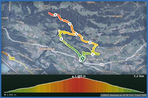
The plotted track follows the marked trails according to OpenStreetMap; see the map, elevation profile and GPX file above. Please follow the signposting on site.
Winter boots, poles, spikes and a thermos; above Goritschang check the avalanche report (lawine-vorarlberg.at). 3½ hours need an early start – it gets dark early in December and January. Dogs welcome.
Landbus Montafon (lines 650/670/680) and Montafonerbahn Bludenz–Schruns; connections at vmobil.at.
Please check parking at the starting point on site (hiking car parks are usually signposted).
Emergency: Alpine rescue 140 · Euro emergency 112 · Ambulance 144
All information without guarantee. Please check weather, opening hours and cable car operating times before setting off. Alpine tours require personal responsibility, suitable equipment and experience.
Last updated: 13 Sep 2026 · Map data © OpenStreetMap contributors (ODbL)
Aerial imagery basemap.at (CC BY 4.0) · track OSM
Bartholomäberg via Rellseck to the Fritzensee
Montafon
 Aerial imagery basemap.at (CC BY 4.0) · track OSM
Bartholomäberg via Neyers-Legi to the historischen Bergwerk
Montafon
Aerial imagery basemap.at (CC BY 4.0) · track OSM
Bartholomäberg via Neyers-Legi to the historischen Bergwerk
Montafon
 Aerial imagery basemap.at (CC BY 4.0) · track OSM
Bartholomäberg to the Rellseck (back via Linda)
Montafon
Aerial imagery basemap.at (CC BY 4.0) · track OSM
Bartholomäberg to the Rellseck (back via Linda)
Montafon