 Aerial imagery basemap.at (CC BY 4.0) · track OSM
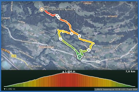
Bartholomäberg via Goritschang to Rellseck
Montafon
Aerial imagery basemap.at (CC BY 4.0) · track OSM
Bartholomäberg via Goritschang to Rellseck
Montafon
moderate ❄️ winter
The big loop on the sun balcony: via Goritschang up to the Rellseck, on to the Fritzensee and back via Fritza Legi – 10.2 km, 501 m of ascent, 3½ hours.
The longest of the Bartholomäberg winter loops links the two finest spots on the sunny slope: the Rellseck and the little Fritzensee. From the baroque church (1,087 m) follow the Lindaweg to the Linda viewpoint on the miners' trail and continue through the Fritzatobel and via Goritschang up to the Rellseck (around 1,495 m), where the Vandanser Steinwand, Zimba and Drei Türme stand before you with the three-thousanders of the Silvretta showing behind. Then it is almost level on to the snow-covered Fritzensee with its view of the Drei Türme, past the Maisäß huts of Fritza Legi and back to the village via Garsella and Sassella. 10.15 km, 501 m of ascent, about 3½ hours, moderate; according to the provincial trail data the paths are mostly cleared, rolled around the Fritzensee. Along the way there are several rest benches made from old chairlift seats with weather hoods.
From our house 20 minutes by car (car park at the church) or bus 650 to Schruns and bus 640 to Bartholomäberg Kirche. The Alpengasthaus Rellseck (Hotel Bergerhof) is not reliably open in winter – phone ahead and pack provisions; otherwise refreshments in Bartholomäberg. Some portals quote up to 12 km for this loop – our figure comes from the GPS track.
The route leads via Aussichtspunkt Linda (Bergknappenweg), Rellseck and Fritzensee and back to the starting point.
The plotted track follows the marked trails according to OpenStreetMap; see the map, elevation profile and GPX file above. Please follow the signposting on site.
The most demanding loop on the sun balcony in terms of fitness: start early, winter boots, poles, spikes, warm drinks. Check the avalanche report at lawine-vorarlberg.at – the section to the Fritzensee lies at almost 1,500 m. Dogs welcome.
Landbus Montafon (lines 650/670/680) and Montafonerbahn Bludenz–Schruns; connections at vmobil.at.
Please check parking at the starting point on site (hiking car parks are usually signposted).
Emergency: Alpine rescue 140 · Euro emergency 112 · Ambulance 144
All information without guarantee. Please check weather, opening hours and cable car operating times before setting off. Alpine tours require personal responsibility, suitable equipment and experience.
Last updated: 13 Sep 2026 · Map data © OpenStreetMap contributors (ODbL)
Aerial imagery basemap.at (CC BY 4.0) · track OSM
Bartholomäberg via Goritschang to Rellseck
Montafon
 Aerial imagery basemap.at (CC BY 4.0) · track OSM
Bartholomäberg via Neyers-Legi to the historischen Bergwerk
Montafon
Aerial imagery basemap.at (CC BY 4.0) · track OSM
Bartholomäberg via Neyers-Legi to the historischen Bergwerk
Montafon
 Aerial imagery basemap.at (CC BY 4.0) · track OSM
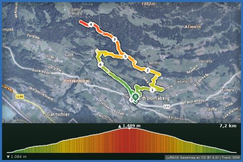
Bartholomäberg to the Rellseck (back via Linda)
Montafon
Aerial imagery basemap.at (CC BY 4.0) · track OSM
Bartholomäberg to the Rellseck (back via Linda)
Montafon