 Aerial imagery basemap.at (CC BY 4.0) · track OSM
Vier Barga winter trail
Montafon
Aerial imagery basemap.at (CC BY 4.0) · track OSM
Vier Barga winter trail
Montafon
moderate ❄️ winter
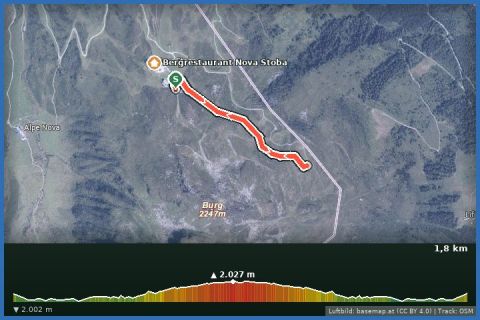
From the Nova Stoba to the Gantakopf viewpoint (1,958 m): 1.7 km of groomed high-level trail above Gaschurn with views of the Verwall – an hour including gazing.
The Versettla Bahn from Gaschurn takes you up to 2,008 m in a few minutes, right next to the Nova Stoba – at around 2,010 m one of the largest mountain restaurants in the Alps, complete with the VINNOVA wine bar. From there the marked winter trail runs along the slope to the Gantakopf viewpoint at 1,958 m and back the same way: 1.7 km, 72 m of ascent, about an hour including stops. Opposite stands the Verwall with the distinctive Valschavieler Maderer; below lie Gaschurn and Partenen – a balcony above the inner Montafon.
The trail belongs to the Silvretta Montafon network and is groomed by the cable car company, not by the state; it is open when the lift is running (winter 2026/27: 3 December 2026 to 11 April 2027) and snow conditions allow. Pedestrians use the Silvretta Montafon "ascent & descent" ticket. Combines well with the neighbouring Vier Barga trail, which also starts at the Nova Stoba. From our house: 5 minutes by car or around 10 minutes on bus 650 to Gaschurn Versettla Bahn.
The route leads via Bergrestaurant Nova Stoba and L19: Nova Stoba, Bergstation Versettla Bahn, Gaschurn and back to the starting point.
The plotted track follows the marked trails according to OpenStreetMap; see the map, elevation profile and GPX file above. Please follow the signposting on site.
The operator recommends good footwear, poles and spikes – the trail is narrow and hard-packed in places. Dress warmly at 2,000 m; check the avalanche situation and trail status (silvretta-montafon.at) beforehand. Dogs on a lead, do not cross the pistes.
Landbus Montafon (lines 650/670/680) and Montafonerbahn Bludenz–Schruns; connections at vmobil.at.
Please check parking at the starting point on site (hiking car parks are usually signposted).
Emergency: Alpine rescue 140 · Euro emergency 112 · Ambulance 144
All information without guarantee. Please check weather, opening hours and cable car operating times before setting off. Alpine tours require personal responsibility, suitable equipment and experience.
Last updated: 14 Sep 2026 · Map data © OpenStreetMap contributors (ODbL)
Aerial imagery basemap.at (CC BY 4.0) · track OSM
Vier Barga winter trail
Montafon
 Aerial imagery basemap.at (CC BY 4.0) · track OSM
Skitour über die Versettla auf die Madrisella
Montafon
Aerial imagery basemap.at (CC BY 4.0) · track OSM
Skitour über die Versettla auf die Madrisella
Montafon
 Aerial imagery basemap.at (CC BY 4.0) · track OSM
Winter walking trail Sonnenbahn
Montafon
Aerial imagery basemap.at (CC BY 4.0) · track OSM
Winter walking trail Sonnenbahn
Montafon