 Aerial imagery basemap.at (CC BY 4.0) · track OSM
Via ferrata Gauablick
Tschagguns
Aerial imagery basemap.at (CC BY 4.0) · track OSM
Via ferrata Gauablick
Tschagguns
moderate · C 🎫 Card
A long, scenically superb Rätikon tour: through the gorge and over limestone slabs to the Drusenfluh (2,827 m).
Together with the Drei Türme, the Drusenfluh forms the backdrop of the Lindauer Hütte, and its via ferrata is one of the long, alpine undertakings of the Rätikon. From the hut you climb through a wild gorge and over stepped limestone slabs; the route is graded D, so it demands strength and technique, and the 1,100 m of ascent make it a day tour of around 5½ to 6 hours. At the top you stand on the border ridge with Switzerland, looking at the Schesaplana, Sulzfluh and Prättigau.
International guides emphasise the scenic class and at the same time warn of rockfall in the gullies and residual snow into July. Descend by the normal route back to the Lindauer Hütte, which is easily reached beforehand by the Golm cable car and the Latschätzer trail.
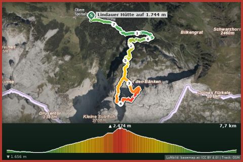
The route leads from Lindauer Hütte via Drusenfluh (2.727 m) and back to the starting point.
The plotted track follows the marked trails according to OpenStreetMap; see the map, elevation profile and GPX file above. Please follow the signposting on site.
Helmet, gloves, early start. If snow remains in the gullies, postpone until later in summer.
Montafonerbahn to Vandans or Tschagguns, Landbus to the Golm cable car in Vandans/Latschau (Golm valley station). From St. Gallenkirch: bus 650 with change in Schruns.
Free parking at the Golm cable car in Vandans and in Latschau (mid station/Gauertal car park, partly paid in summer).
Emergency: Alpine rescue 140 · Euro emergency 112 · Ambulance 144
All information without guarantee. Please check weather, opening hours and cable car operating times before setting off. Alpine tours require personal responsibility, suitable equipment and experience.
Last updated: 13 Sep 2026 · Map data © OpenStreetMap contributors (ODbL)
Aerial imagery basemap.at (CC BY 4.0) · track OSM
Via ferrata Gauablick
Tschagguns
 Aerial imagery basemap.at (CC BY 4.0) · track OSM
Partnunblick via ferrata
Tschagguns
Aerial imagery basemap.at (CC BY 4.0) · track OSM
Partnunblick via ferrata
Tschagguns
 Aerial imagery basemap.at (CC BY 4.0) · track OSM
Sulzfluh via ferrata
Tschagguns
Aerial imagery basemap.at (CC BY 4.0) · track OSM
Sulzfluh via ferrata
Tschagguns