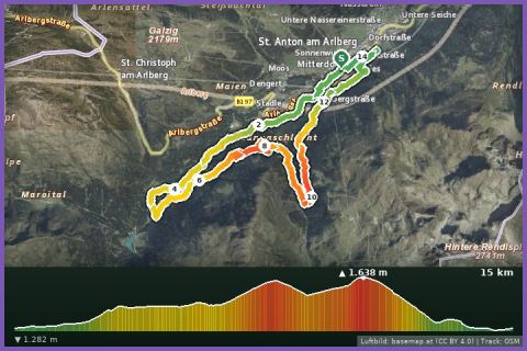
 Aerial imagery basemap.at (CC BY 4.0) · track OSM
T15 Panorama Trail 15 km (Montafon Arlberg Marathon St. Anton am Arlberg)
St. Anton am Arlberg · Arlberg
Aerial imagery basemap.at (CC BY 4.0) · track OSM
T15 Panorama Trail 15 km (Montafon Arlberg Marathon St. Anton am Arlberg)
St. Anton am Arlberg · Arlberg
difficult
The current race course: 41.6 km from St. Anton through the Verwall over the Winterjöchle (1,955 m) into the Silbertal – 1,250 m of ascent. Next date 26 June 2027.
The Montafon Arlberg Marathon has linked two Austrian provinces across a pass since 2003, and since 2019 it has been run in this direction: start at the tourist office in St. Anton am Arlberg, into the Rosanna gorge with its rooty, cable-protected paths, then on broad natural tracks through the Verwall valley past the Konstanzer Hütte and the turquoise Verwallsee, over Schönverwall to the Langsee and up to the Winterjöchle – at 1,955 m the highest point and also the most technical stretch, with rock, grass and wet ground. Then comes the long descent through the Gafluna valley via the Fresch Alpe and Gafluna to the Fellimännle alpine inn and along the Teufelsbach waterfall to the finish at the fire station in Silbertal. 41.6 km, 1,250 m of climbing, 1,630 m of descent, entirely within the Verwall Natura 2000 area; the 8 hours in our fact box is a hiking guide value, the race closes at 17:00 with a cut-off at 14:00 at Fellimännle (km 28.7).
The organiser is Montafon Tourismus; besides the marathon there are the T33 Trail (33 km, 1,150 m of ascent), a panorama trail (15 km) from Silbertal, a hiking category and the kids' trail. The 23rd edition took place on 27 June 2026, the next is scheduled for 26 June 2027. St. Anton is 63 minutes by car from our house, or by Montafonerbahn and ÖBB via Bludenz; the finish in Silbertal is 21 minutes from us.
The route leads via Langsee and Talstation Montafoner Kristbergbahn.
The plotted track follows the marked trails according to OpenStreetMap; see the map, elevation profile and GPX file above. Please follow the signposting on site.
Outside the race you are on your own: 1.5 to 2 litres of water, food, rain and warm layers, poles and a phone; the huts in the Verwall are staffed from late June to late September. Walkers have priority; return from Silbertal on bus 680.
Landbus Montafon (lines 650/670/680) and Montafonerbahn Bludenz–Schruns; connections at vmobil.at.
Please check parking at the starting point on site (hiking car parks are usually signposted).
Last updated: 13 Sep 2026 · Map data © OpenStreetMap contributors (ODbL)
Aerial imagery basemap.at (CC BY 4.0) · track OSM
T15 Panorama Trail 15 km (Montafon Arlberg Marathon St. Anton am Arlberg)
St. Anton am Arlberg · Arlberg
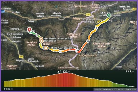 Aerial imagery basemap.at (CC BY 4.0) · track OSM
T33 Trail 33 km (Montafon Arlberg Marathon St. Anton at the Arlberg)
St. Anton / Silbertal · Vorarlberg
Aerial imagery basemap.at (CC BY 4.0) · track OSM
T33 Trail 33 km (Montafon Arlberg Marathon St. Anton at the Arlberg)
St. Anton / Silbertal · Vorarlberg
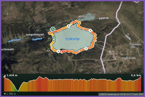 Aerial imagery basemap.at (CC BY 4.0) · track OSM
Kopssee Loop
Montafon
Aerial imagery basemap.at (CC BY 4.0) · track OSM
Kopssee Loop
Montafon