 Aerial imagery basemap.at (CC BY 4.0) · track OSM
Montafon Arlberg Marathon 42 km – Start: St. Anton am Arlberg
Montafon · Vorarlberg
Aerial imagery basemap.at (CC BY 4.0) · track OSM
Montafon Arlberg Marathon 42 km – Start: St. Anton am Arlberg
Montafon · Vorarlberg
difficult
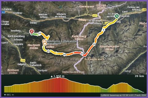
The current T33 course of the Montafon Arlberg Marathon: 33.4 km from St. Anton via the Verwallsee, Langsee and Winterjöchle to Silbertal – 780 m up, 1,150 m down.
The T33 Trail is the middle distance of the Montafon Arlberg Marathon, staged at the end of June by Montafon Tourismus (in 2026 on 27 June, around 900 participants across all races). Since 2019 the marathon and the T33 have run from St. Anton am Arlberg (1,284 m) to Silbertal: through the Verwall valley past the Verwallsee, through the Schönverwall to the Langsee and up to the Silbertaler Winterjöchle on the provincial border between Tyrol and Vorarlberg – at around 1,950 m the highest point of the course. Then comes the long descent through the Verwall European protected area: Fresch alp, Untere Gafluna alp, the Fellimännle inn, the Teufelsbach waterfall and through Silbertal to the finish at the fire station and sports ground. According to the track 33.4 km, 780 m of ascent and 1,150 m of descent; guideline 5 hours 45 minutes walking time, and in the race the course closes at 5 pm.
The crossing of the Winterjöchle has been used as a link between the two valleys since the late 18th century; today it is a car-free route of forest roads and narrow mountain paths where, apart from the alps, you meet only grazing cattle and marmots. As a training run the route needs logistics: from Silbertal bus 680 takes you to Schruns, the Montafonerbahn to Bludenz and ÖBB trains to St. Anton (from the holiday house via Schruns about 35 minutes to Silbertal). Refreshments at the Verwallsee, at the Fellimännle and in Silbertal.
The route leads via Langsee, Schwarzsee in Silbertal and Almhütte Fellimännle.
The plotted track follows the marked trails according to OpenStreetMap; see the map, elevation profile and GPX file above. Please follow the signposting on site.
Between the Verwallsee and the Gafluna alp you have around 20 km without any refreshment stop – pack a hydration pack, food and a rain and wind jacket. Patches of snow at the Winterjöchle are possible into June. Walkers have priority on the narrow paths; poles make the long descent easier.
Landbus Montafon (lines 650/670/680) and Montafonerbahn Bludenz–Schruns; connections at vmobil.at.
Please check parking at the starting point on site (hiking car parks are usually signposted).
Last updated: 13 Sep 2026 · Map data © OpenStreetMap contributors (ODbL)
Aerial imagery basemap.at (CC BY 4.0) · track OSM
Montafon Arlberg Marathon 42 km – Start: St. Anton am Arlberg
Montafon · Vorarlberg
 Aerial imagery basemap.at (CC BY 4.0) · track OSM
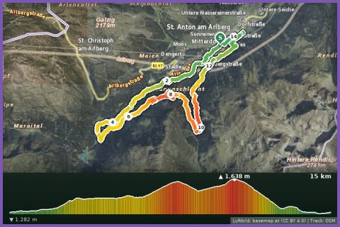
T15 Panorama Trail 15 km (Montafon Arlberg Marathon St. Anton am Arlberg)
St. Anton am Arlberg · Arlberg
Aerial imagery basemap.at (CC BY 4.0) · track OSM
T15 Panorama Trail 15 km (Montafon Arlberg Marathon St. Anton am Arlberg)
St. Anton am Arlberg · Arlberg
 Aerial imagery basemap.at (CC BY 4.0) · track OSM
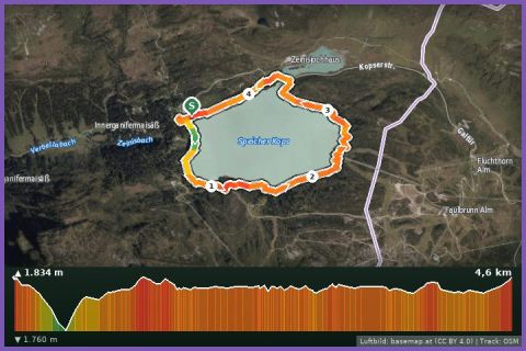
Kopssee Loop
Montafon
Aerial imagery basemap.at (CC BY 4.0) · track OSM
Kopssee Loop
Montafon