 Aerial imagery basemap.at (CC BY 4.0) · track OSM
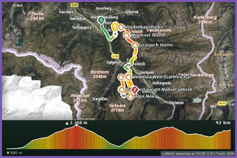
Montafon Totale Ultra 45: 45 kilometres, 3,750 m of ascent
Schruns
Aerial imagery basemap.at (CC BY 4.0) · track OSM
Montafon Totale Ultra 45: 45 kilometres, 3,750 m of ascent
Schruns
difficult 🎫 Card
The long course of the Montafon Totale Trail: 31 km and 3,000 m of ascent from Schruns over Sennigrat, Kreuzjoch (2,396 m) and Grasjoch to the Nova Stoba.
The Trail 31 is the big course of the Montafon Totale Trail, the Silvretta Montafon trail-running race: 31 km, 3,000 m of climbing and 1,660 m of descent, from 682 m in the centre of Schruns up to 2,396 m at the Kreuzjoch. The first climb passes the Kapellrestaurant up to the Sennigrat, then comes the finest section: flowing singletrack over the green grassy ridge past the Zamangspitze to the Kreuzjoch, and on along the Wormser Höhenweg to the Grasjoch Hütte. Then the long descent to St. Gallenkirch (parish church, Brunellawirt) and the second big climb via the Maisäß hamlet of Garfrescha and the Gantekopf (1,958 m) to the finish at the Nova Stoba mountain restaurant. Alpine paths, grass ridge and forest tracks in turn; the 8½ hours in our fact box is a hiking guide value. German running magazines describe the course as hard but exceptional in scenery; the Versettla Bahn or the Valisera Bahn take you down to the valley.
The 2026 edition took place on 4 July, the next is scheduled for 3 July 2027, also as a two-person relay. For training the course can be split: the Hochjoch Bahn in Schruns (summer 2026: 13 June to 26 October) or the Grasjoch Bahn in St. Gallenkirch (4 July to 13 September) save you one climb. Schruns is 12 minutes from our house, and the St. Gallenkirch section passes almost by our door.
The route leads via Kapellrestaurant, Grasjoch Hütte, Pfarrkirche St. Gallenkirch, Brunellawirt, Gantakopf (1.958 m) and Bergrestaurant Nova Stoba.
The plotted track follows the marked trails according to OpenStreetMap; see the map, elevation profile and GPX file above. Please follow the signposting on site.
High alpine and long: set off only in stable weather, with 1.5 to 2 litres of water, food, rain and warm layers, gloves and poles; on the ridge between Sennigrat and Kreuzjoch there is no shelter in a thunderstorm. Walkers have priority on the high-level paths.
Montafonerbahn to Schruns station (every 30 min from Bludenz), Hochjoch cable car a 5-minute walk; Landbus 650 from St. Gallenkirch approx. 15 min.
Parking at the Hochjoch cable car in Schruns is paid and limited; alternative free parking at the Zamang cable car.
Last updated: 13 Sep 2026 · Map data © OpenStreetMap contributors (ODbL)
Aerial imagery basemap.at (CC BY 4.0) · track OSM
Montafon Totale Ultra 45: 45 kilometres, 3,750 m of ascent
Schruns
 Aerial imagery basemap.at (CC BY 4.0) · track OSM
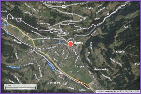
Tandem paragliding (Flyingfor2)
Schruns / Gaschurn
Aerial imagery basemap.at (CC BY 4.0) · track OSM
Tandem paragliding (Flyingfor2)
Schruns / Gaschurn
 Aerial imagery basemap.at (CC BY 4.0) · track OSM
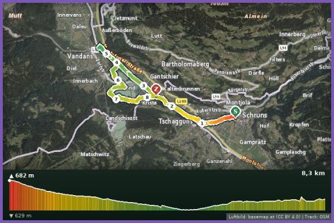
Litz Promenade, Ill Path and Lakes Loop
Schruns
Aerial imagery basemap.at (CC BY 4.0) · track OSM
Litz Promenade, Ill Path and Lakes Loop
Schruns