 Aerial imagery basemap.at (CC BY 4.0) · track OSM
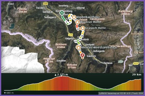
Montafon Totale Trail 31: 31 km, 3,000 m of ascent
Schruns
Aerial imagery basemap.at (CC BY 4.0) · track OSM
Montafon Totale Trail 31: 31 km, 3,000 m of ascent
Schruns
difficult 🎫 Card
The flagship distance of the Montafon Totale Trail: 44.5 km and 3,750 m of ascent from Schruns over Kreuzjoch, Grasjoch, Garfrescha and Valisera to Nova Stoba.
The Ultra is the longest course of the Montafon Totale Trail, which Silvretta Montafon stages every year in early July (in 2026 on 4 July, start 7 am in the centre of Schruns). From 683 m in the valley the route climbs via Kapell and the Sennigrat to the Kreuzjoch (2,395 m), follows the Wormser Weg to the Grasjoch and then makes the long drop to St. Gallenkirch – running right through our village. The second big climb follows via Garfrescha to Valisera, on to the Serres lake and Alpe Nova, down once more to Garfrescha and over the Gantakopf to the finish at Nova Stoba at around 2,000 m. According to the track it is 44.5 km with 3,750 m of ascent and 2,417 m of descent; as a hike that would be a guideline of a good 11 hours; in the race there are eleven hours until the course closes at 6 pm.
As a training route the Ultra splits neatly into two halves: Schruns–St. Gallenkirch (the Hochjoch or Grasjoch cable cars shorten it) and St. Gallenkirch–Nova Stoba, from where the Versettla cable car takes you down to Gaschurn. From our house you are on the second half within minutes – the Garfrescha cable car is 600 m away. Refreshments are available at Kapell, the Wormser Hütte, the Grasjoch Hütte, the Valisera Hüsli, Alpe Nova and Nova Stoba; during the race there are nine aid stations.
The route leads via Im Dorf.
The plotted track follows the marked trails according to OpenStreetMap; see the map, elevation profile and GPX file above. Please follow the signposting on site.
Mandatory race kit: switched-on mobile phone, at least a 0.5 l drinks container, rain jacket, emergency blanket and trail shoes – just as sensible for training runs. Between Kreuzjoch and Grasjoch and around the Madrisella you are above 2,000 m for a long time with no shelter from a change in the weather, so start early. Summer 2026 cable cars: Hochjoch until 26 Oct, Grasjoch until 13 Sept, Versettla until 4 Oct.
Montafonerbahn to Schruns station (every 30 min from Bludenz), Hochjoch cable car a 5-minute walk; Landbus 650 from St. Gallenkirch approx. 15 min.
Parking at the Hochjoch cable car in Schruns is paid and limited; alternative free parking at the Zamang cable car.
Last updated: 13 Sep 2026 · Map data © OpenStreetMap contributors (ODbL)
Aerial imagery basemap.at (CC BY 4.0) · track OSM
Montafon Totale Trail 31: 31 km, 3,000 m of ascent
Schruns
 Aerial imagery basemap.at (CC BY 4.0) · track OSM
Tandem paragliding (Flyingfor2)
Schruns / Gaschurn
Aerial imagery basemap.at (CC BY 4.0) · track OSM
Tandem paragliding (Flyingfor2)
Schruns / Gaschurn
 Aerial imagery basemap.at (CC BY 4.0) · track OSM
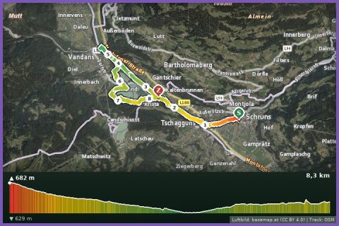
Litz Promenade, Ill Path and Lakes Loop
Schruns
Aerial imagery basemap.at (CC BY 4.0) · track OSM
Litz Promenade, Ill Path and Lakes Loop
Schruns