 Aerial imagery basemap.at (CC BY 4.0) · track OSM
Ganlätsch Loop
Silbertal
Aerial imagery basemap.at (CC BY 4.0) · track OSM
Ganlätsch Loop
Silbertal
moderate
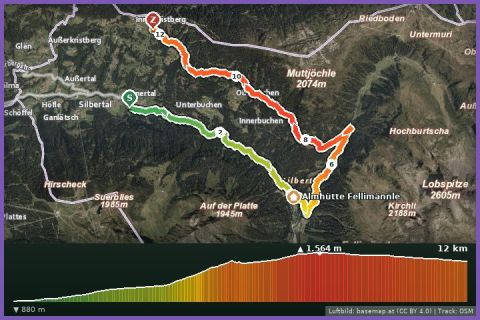
Vertical in the Silbertal: 6.5 km and 656 m of ascent from the village via the Oberbuchen alp and Siebenbrünnele to the Kristbergbahn top station.
The Silbertal-Kristberg Trail is the climb from the village to the sunny balcony of the Silbertal. From the sports ground (872 m) you run through the centre of Silbertal (889 m), out along the Buchenstraße and then steeply through the forest to the Oberbuchen alp. Across alpine meadows you reach the “Sieba Brünna” Kneipp facility and finally the top station of the Kristbergbahn at around 1,440 m; the highest point according to the track is 1,529 m. According to the track 6.5 km, 656 m of ascent and 96 m of descent, guideline 1 hour 35 minutes walking time. According to OpenStreetMap asphalt in the village, gravel tracks and mountain hiking paths alternate – the forest section is steep and partly rooty, hence “hard”.
At the top the view back into the valley and across to the Lobspitze and the Verwall is worth it; refreshments at the Panoramagasthof on the Kristberg. You go back down with the Kristbergbahn (summer operation 2026: 1 May to 1 November, included in the Freizeit-WildPass). If you want to keep running at the top, add the flat Wildried high-level route. From our house it is 16 km or around 20 minutes by car; by buses 650 and 680 via Schruns about 35 minutes to the Kristbergbahn valley station, from where it is 900 m to the sports ground.
The plotted track follows the marked trails according to OpenStreetMap; see the map, elevation profile and GPX file above. Please follow the signposting on site.
The forest path is slippery after rain; poles help. Water is available at the Kneipp facility; until then carry a hydration pack. Check the last descent of the Kristbergbahn – alternatively walk down on the hiking trail.
Landbus 680 Schruns–Silbertal to the Kristberg cable car valley station; hiking bus into the upper Silbertal (summer). From St. Gallenkirch via Schruns approx. 35 min.
Free car park at the Kristberg cable car in Silbertal.
Last updated: 13 Sep 2026 · Map data © OpenStreetMap contributors (ODbL)