 Aerial imagery basemap.at (CC BY 4.0) · track OSM
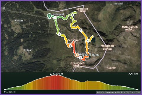
Trail run Seetal Hochjoch
Silbertal
Aerial imagery basemap.at (CC BY 4.0) · track OSM
Trail run Seetal Hochjoch
Silbertal
moderate 🎫 Card
13 km high-level run from the Grasjoch over the Kreuzjoch (2,395 m) past the Wormser Hütte and through the Seetal to Kapell – 842 m up, 962 m down, lifts at both ends.
The Panoramatour is the big traverse of the Hochjoch area – and it starts practically at our door: the Grasjoch cable car in St. Gallenkirch is 2 km from the holiday house and takes you to the top station on the Grasjoch (1,975 m), where the route begins. Over the Hochalpila ridge the path climbs to the crest and follows it north to the Kreuzjoch (2,395 m), the highest point, with views over the whole Montafon, the Rätikon and the Silvretta. A few minutes further on is the Wormser Hütte (2,307 m, DAV Worms section), then the trail drops into the Seetal past the Schwarzsee and Kälbersee and loops through the alps below Kapell to the top station of the Hochjoch cable car (1,855 m). According to the track 13.0 km, 842 m of ascent and 962 m of descent, guideline 3 hours 20 minutes walking time; alpine paths with rock and boulder sections on the ridge, alp tracks lower down – VoGIS rates the route as hard.
From Kapell take the Hochjoch cable car down to Schruns (summer 2026 until 26 October) and bus 650 back to St. Gallenkirch in 15 minutes; the Grasjoch cable car runs in summer 2026 from 4 July to 13 September. Refreshments at the Grasjoch Hütte, the Wormser Hütte and the Kapell restaurant. To shorten the descent, take the variant via the Sennigrat chairlift from the Kreuzjoch.
The route leads via Kapellrestaurant, L7: Kapellrestaurant, Bergstation Hochjoch Bahn, Schruns, Schwarzsee auf dem Hochjoch, Hochalpila and Kälbersee auf dem Hochjoch.
The plotted track follows the marked trails according to OpenStreetMap; see the map, elevation profile and GPX file above. Please follow the signposting on site.
Only in settled weather: the crest between Hochalpila and Kreuzjoch is long, exposed and without shelter. Sure-footedness, poles, wind and rain jacket, hydration pack (the next water is at the Wormser Hütte). Walkers have priority on the ridge path; check the operating hours of both cable cars before you start.
Landbus Montafon (lines 650/670/680) and Montafonerbahn Bludenz–Schruns; connections at vmobil.at.
Please check parking at the starting point on site (hiking car parks are usually signposted).
Last updated: 13 Sep 2026 · Map data © OpenStreetMap contributors (ODbL)
Aerial imagery basemap.at (CC BY 4.0) · track OSM
Trail run Seetal Hochjoch
Silbertal
 Aerial imagery basemap.at (CC BY 4.0) · track OSM
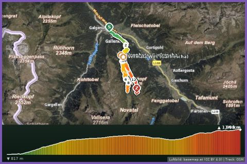
Montafon Totale Trail 16: 16 km, 1,450 m of ascent
St. Gallenkirch
Aerial imagery basemap.at (CC BY 4.0) · track OSM
Montafon Totale Trail 16: 16 km, 1,450 m of ascent
St. Gallenkirch
 Aerial imagery basemap.at (CC BY 4.0) · track OSM
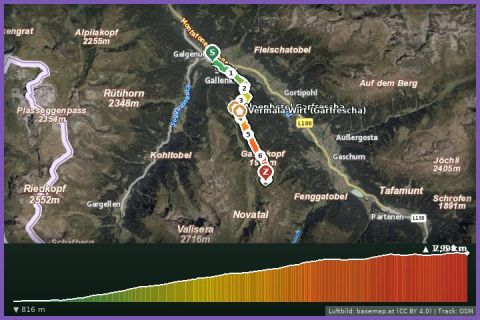
Montafon Totale Mountain Run 10: 10 km, 1,200 m of ascent
St. Gallenkirch
Aerial imagery basemap.at (CC BY 4.0) · track OSM
Montafon Totale Mountain Run 10: 10 km, 1,200 m of ascent
St. Gallenkirch